
Bestand:Haiti und Dominikanische Republik - Gebietsentwicklung.png

Grootte van deze voorvertoning: 800 × 367 pixels. Andere resoluties: 320 × 147 pixels | 640 × 294 pixels | 1.024 × 470 pixels | 1.891 × 868 pixels.
Oorspronkelijk bestand (1.891 × 868 pixels, bestandsgrootte: 228 kB, MIME-type: image/png)
| Dit is een bestand van Wikimedia Commons. Onderstaande beschrijving komt van de beschrijving van het bestand daar. |
| Beschrijving |
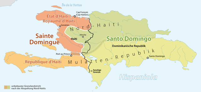
Deutsch: Gebietsentwicklung von Haiti
English: History of the territorial changes of Haiti |
| Datum | see file history |
| Bron | Eigen werk, using File:Haiti location map.svg by Alexrk and File:Dominican Republic location map.svg by Alexrk |
| Auteur | Maximilian Dörrbecker (Chumwa) |
| Toestemming (Hergebruik van dit bestand) |
Dit bestand is gelicenseerd onder de Creative Commons-licentie Naamsvermelding-Gelijk delen 2.0 Unported
|
| Andere versies |
|

.png)


Bestandsgeschiedenis
Klik op een datum/tijd om het bestand te zien zoals het destijds was.
| Datum/tijd | Miniatuur | Afmetingen | Gebruiker | Opmerking | |
|---|---|---|---|---|---|
| huidige versie | 17 mrt 2011 00:28 | | 1.891 × 868 (228 kB) | Chumwa | Korrektur: Republic d'Haïti → République d'Haïti |
| 12 mrt 2011 08:54 |  | 1.893 × 859 (226 kB) | Chumwa | {{Information |Description={{ de }} Gebietsentwicklung von Haiti {{ en }} History of the teritorial changes of Haiti |Author=Maximilian Dörrbecker (Chumwa) |Source={{own}}, using File:Haiti location map.svg by |
Bestandsgebruik
Dit bestand wordt op de volgende pagina gebruikt:
Globaal bestandsgebruik
De volgende andere wiki's gebruiken dit bestand:
- Gebruikt op ar.wikipedia.org
- Gebruikt op de.wikipedia.org
- Gebruikt op en.wikipedia.org
- Gebruikt op es.wikipedia.org
- Gebruikt op id.wikipedia.org