Naar inhoud springen

Bestand:Hawaje.jpg

Pagina-inhoud wordt niet ondersteund in andere talen.
Uit Wikipedia, de vrije encyclopedie

Oorspronkelijk bestand(3.600 × 2.800 pixels, bestandsgrootte: 1,16 MB, MIME-type: image/jpeg)


Beschrijving

Beschrijving
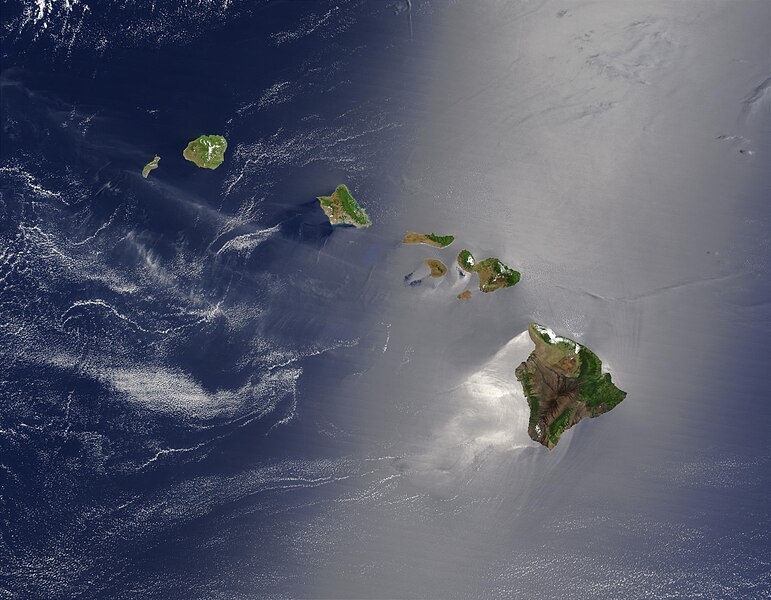
English: Satellite view of Hawaii archipellago (USA).

Original description from NASA:

"A silver swath of sunglint surrounds half of the Hawaiian islands in this true-color Terra MODIS image acquired on May 27, 2003. Sunglint reveals turbulence in the surface waters of the Pacific Ocean. If the surface of the water was as smooth as a perfect mirror, we would see the circle of the Sun as a perfect reflection. But because the surface of the water is ruffled with waves, each wave acts like a mirror and the Sun’s reflection gets softened into a broader silver swath, called the sunglint region.

"In this scene, the winds ruffling the water surface around the Hawaiian Islands create varying patterns, leaving some areas calmer than others. Southwest of Hawaii and Maui, on their leeward sides, calmer waters are indicated by brighter silver coloration. Conversely, notice how most of the vegetation on the Hawaiian Islands grows on their northeastern, or windward, sides.

"From lower right to upper left, the “Big Island” (Hawaii), Maui, Kahoolawe, Lanai, Molokai, Oahu, Kauai, and Niihau islands all make up the state of Hawaii, which lies more than 2,000 miles from any other part of the United States. The small red dot on the Big Island’s southeastern side marks a hot spot on Kilauea Volcano’s southern flank. Kilauea has been erupting almost continuously since January 1983, and is one of the world’s best studied volcanoes."
Français : Vue satellite de l'archipel d'Hawaï (États-Unis).
Datum
Bron NASA. Image courtesy Jacques Descloitres, MODIS Land Rapid Response Team at NASA GSFC. (IotD Date: 2003-06-03. IotD ID: 15304)
Auteur Jacques Descloitres
Andere versies
Modified version
Dit is een geretoucheerde foto, wat betekent dat de originele versie digitaal aangepast is. Aanpassingen: cloned out and healed little red line on the big island. Het origineel kan hier bekeken worden: Hawaje.jpg. Aanpassingen gedaan door IdLoveOne.

Derivative works

Afgeleide werken van dit bestand:  Hawaje-NoRedLine.jpg

Licentie

Public domain Dit bestand bevindt zich in het publiek domein, omdat het gemaakt is door de NASA. In de reproductierichtlijnen van de NASA staat dat "NASA-materiaal niet beschermd wordt door auteursrecht, tenzij anders vermeld".

(NASA copyright policy page of JPL Image Use Policy).

Waarschuwingen:
  • Het gebruik van logo's, insignes en emblemen van de NASA wordt beperkt door de Amerikaanse wet 14 CFR 1221.
  • Op de website van de NASA staat een groot aantal afbeeldingen van het Sovjet-/Russisch ruimteagentschap en andere niet-Amerikaanse ruimteagentschappen. Deze afbeeldingen bevinden zich niet noodzakelijk in het publieke domein.
  • Materiaal dat gebaseerd is op gegevens van de ruimtetelescoop Hubble wordt mogelijk beschermd door auteursrecht als dit niet expliciet vervaardigd is door het STScI [1]. Zie tevens {{PD-Hubble}} en {{Cc-Hubble}} of {{Spacetelescope.org}}.
  • Het gemeenschappelijk project van ESA en NASA betreffende de ruimtesonde SOHO suggereert dat al het materiaal dat gemaakt is door zijn ruimtesonde beschermd wordt door auteursrecht en dat toestemming vereist is voor commercieel niet-educatief gebruik. [2]
  • Afbeeldingen op de Astronomy Picture of the Day-website (APOD) worden mogelijk beschermd door auteursrecht. [3]

Bijschriften

Beschrijf in één regel wat dit bestand voorstelt

Items getoond in dit bestand

beeldt af

Bestandsgeschiedenis

Klik op een datum/tijd om het bestand te zien zoals het destijds was.

Datum/tijdMiniatuurAfmetingenGebruikerOpmerking
huidige versie26 okt 2005 20:19Miniatuurafbeelding voor de versie van 26 okt 2005 20:193.600 × 2.800 (1,16 MB)PalladinusHawaii Islands

Geen enkele pagina gebruikt dit bestand.

Globaal bestandsgebruik

De volgende andere wiki's gebruiken dit bestand:

Metadata