
Bestand:High Bridge Farmville Virginia.jpg

Grootte van deze voorvertoning: 776 × 599 pixels. Andere resoluties: 311 × 240 pixels | 622 × 480 pixels | 995 × 768 pixels | 1.280 × 989 pixels | 2.560 × 1.977 pixels | 6.653 × 5.138 pixels.
Oorspronkelijk bestand (6.653 × 5.138 pixels, bestandsgrootte: 15,25 MB, MIME-type: image/jpeg)
| Dit is een bestand van Wikimedia Commons. Onderstaande beschrijving komt van de beschrijving van het bestand daar. |
Beschrijving
|
Dit is een foto van een object in het National Register of Historic Places met nummer 8000875. |
| Beschrijving |
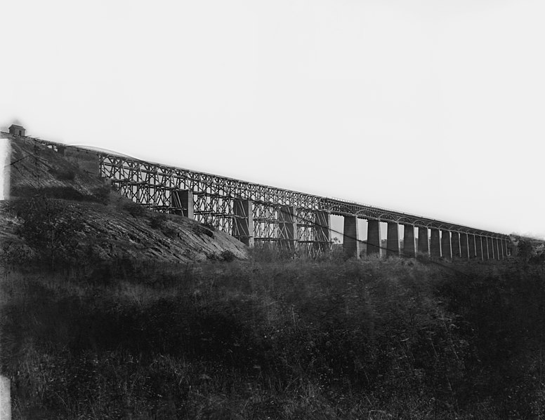
English: Farmville, Virginia (vicinity). High bridge of the South Side Railroad across the Appomattox. NOTE: Title from Civil War caption books. Caption from negative sleeve: High Bridge across Appomattox River, south side railroad. Farmvill, Va., (vicinity) April 1865. Forms part of Civil War glass negative collection of the Library of Congress. No known restrictions on publication. |
||||||||||||||||||||||||||
| Datum | Genomen in april 1865 | ||||||||||||||||||||||||||
| Bron |
https://www.loc.gov/pictures/resource/cwpb.03733/
|
||||||||||||||||||||||||||
| Auteur |
|
||||||||||||||||||||||||||
| Toestemming (Hergebruik van dit bestand) |
No known restrictions on publication. | ||||||||||||||||||||||||||


| Objectlocatie | | Deze en andere afbeeldingen in: OpenStreetMap |
|---|
Transwiki information
Previously uploaded by Hlj to en.wikipedia on 2006-08-23. Verplaatst vanaf en.wikipedia naar Commons. Image cropped by Hal Jespersen. Transwiki approved by: w:en:User:Multichill
Image description page history
| link | date/time | username | edit summary |
|---|---|---|---|
| [1] | 11:06, 22 February 2008 | w:en:User:Multichill | |
| [2] | 12:16, 12 September 2007 | w:en:User:Parsecboy | |
| [3] | 17:14, 3 May 2007 | w:en:User:165.139.9.56 | |
| [4] | 23:21, 23 August 2006 | w:en:User:Hlj | (Image cropped by Hal Jespersen. TITLE: Farmville, Virginia (vicinity). High bridge of the South Side Railroad across the Appomattox CALL NUMBER: LC-B817- 7179[P&P] REPRODUCTION NUMBER: LC-DIG-cwpb-03733 (digital file from original neg.) No known res) |
![[1]](https://en.wikipedia.org/w/index.php?title=Image:High_Bridge_Farmville_Virginia.jpg&redirect=no&oldid=193248333)
![[2]](https://en.wikipedia.org/w/index.php?title=Image:High_Bridge_Farmville_Virginia.jpg&redirect=no&oldid=157362212)
![[3]](https://en.wikipedia.org/w/index.php?title=Image:High_Bridge_Farmville_Virginia.jpg&redirect=no&oldid=127997968)
![[4]](https://en.wikipedia.org/w/index.php?title=Image:High_Bridge_Farmville_Virginia.jpg&redirect=no&oldid=71483915)
Oorspronkelijk uploadlogboek
| date/time | username | resolution | size | edit summary |
|---|---|---|---|---|
| 23:21, 23 August 2006 | w:en:User:Hlj | 904×629 | 115 KB | Image cropped by Hal Jespersen. TITLE: Farmville, Virginia (vicinity). High bridge of the South Side Railroad across the Appomattox CALL NUMBER: LC-B817- 7179[P&P] REPRODUCTION NUMBER: LC-DIG-cwpb-03733 (digital file from original neg.) No known res |
Licentie
Dit werk bevindt zich in het publiek domein in de Verenigde Staten omdat het gepubliceerd werd (of geregistreerd bij de U.S. Copyright Office) voor 1 januari 1929.
Werken in het publiek domein moeten zowel vrij van auteursrechten zijn in de Verenigde Staten als in het land van herkomst van het werk om te worden gehost op Commons. Indien het werk geen Amerikaans werk is, moet het bestand een aanvullende copyright tag hebben met de auteursrechtelijke status in het land van herkomst.
|
Bestandsgeschiedenis
Klik op een datum/tijd om het bestand te zien zoals het destijds was.
| Datum/tijd | Miniatuur | Afmetingen | Gebruiker | Opmerking | |
|---|---|---|---|---|---|
| huidige versie | 4 mei 2020 01:54 | | 6.653 × 5.138 (15,25 MB) | Taterian | higher resolution |
| 25 feb 2008 20:41 |  | 904 × 629 (115 kB) | BetacommandBot | Transwiki approved by: w:en:User:Multichill {{Information |Description={{en|Image cropped by Hal Jespersen. TITLE: Farmville, Virginia (vicinity). High bridge of the South Side Railroad across the Appomattox CALL NUMBER: LC-B817- 7179[P&P] REP |
Bestandsgebruik
Dit bestand wordt op de volgende 2 pagina's gebruikt:
Globaal bestandsgebruik
De volgende andere wiki's gebruiken dit bestand:
- Gebruikt op en.wikipedia.org
- Farmville, Virginia
- Appomattox campaign
- Battle of High Bridge
- High Bridge (Appomattox River)
- High Bridge Trail State Park
- List of bridges on the National Register of Historic Places in Virginia
- National Register of Historic Places listings in Cumberland County, Virginia
- National Register of Historic Places listings in Prince Edward County, Virginia
- Gebruikt op en.wikivoyage.org
- Gebruikt op es.wikipedia.org
- Gebruikt op ja.wikipedia.org
- Gebruikt op ru.wikipedia.org
- Gebruikt op sv.wikipedia.org
- Gebruikt op www.wikidata.org