
Bestand:JerusalemFarWest1870s.jpg

Oorspronkelijk bestand (1.200 × 898 pixels, bestandsgrootte: 441 kB, MIME-type: image/jpeg)
| Dit is een bestand van Wikimedia Commons. Onderstaande beschrijving komt van de beschrijving van het bestand daar. |
Beschrijving
| Beschrijving |
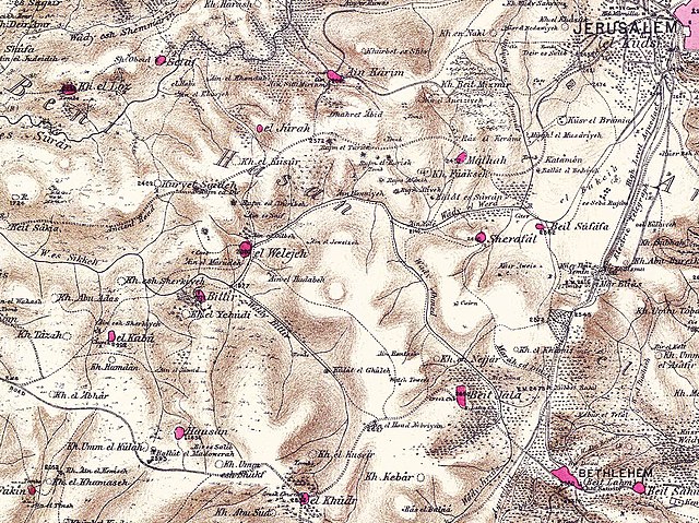
English: Region west of Jerusalem in the 1870s |
||||
| Datum | jaren 1870 | ||||
| Bron |
Palestine Exploration Fund map, sheet 17. Map of survey carried out between 1871 and 1878 by the Palestine Exploration Fund, published in 26 sections in 1880. |
||||
| Auteur | PEF | ||||
| Toestemming (Hergebruik van dit bestand) |
|
||||
Licentie
|
Het tweedimensionale kunstwerk afgebeeld op deze afbeelding valt in het publiek domein omdat:
Reproducties van het werk kunnen ook worden beschouwd als publiek domein omdat ze geen oorspronkelijk karakter hebben. Dit geldt voor reproducties gemaakt in de Verenigde Staten (zie Bridgeman Art Library v. Corel Corp.), Duitsland en veel andere landen.
| ||||
Bestandsgeschiedenis
Klik op een datum/tijd om het bestand te zien zoals het destijds was.
| Datum/tijd | Miniatuur | Afmetingen | Gebruiker | Opmerking | |
|---|---|---|---|---|---|
| huidige versie | 20 apr 2010 15:32 | | 1.200 × 898 (441 kB) | Zero0000 | {{Information |Description=Region west of Jerusalem in the 1870s |Source=Palestine Exploration Fund map, sheet 17. |Date=1870s |Author=PEF |Permission={{PD-old}} |other_versions= }} Category:Maps of Palestine in 19th century [[Category:Maps of Jerusa |
Bestandsgebruik
Dit bestand wordt op de volgende pagina gebruikt:
Globaal bestandsgebruik
De volgende andere wiki's gebruiken dit bestand:
- Gebruikt op ar.wikipedia.org
- Gebruikt op arz.wikipedia.org
- Gebruikt op az.wikipedia.org
- Gebruikt op ca.wikipedia.org
- Gebruikt op en.wikipedia.org
- Gebruikt op es.wikipedia.org
- Gebruikt op fa.wikipedia.org
- Gebruikt op id.wikipedia.org
- Gebruikt op no.wikipedia.org
- Gebruikt op pl.wikipedia.org
- Gebruikt op ur.wikipedia.org
- Gebruikt op www.wikidata.org