
Bestand:Litorale Adriatico.svg

Afmetingen van deze voorvertoning van het type PNG van dit SVG-bestand: 510 × 600 pixels Andere resoluties: 204 × 240 pixels | 408 × 480 pixels | 653 × 768 pixels | 871 × 1.024 pixels | 1.742 × 2.048 pixels | 3.360 × 3.950 pixels.
Oorspronkelijk bestand (SVG-bestand, nominaal 3.360 × 3.950 pixels, bestandsgrootte: 924 kB)
| Dit is een bestand van Wikimedia Commons. Onderstaande beschrijving komt van de beschrijving van het bestand daar. |
Beschrijving
| Beschrijving |
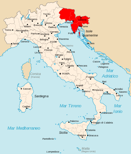
English: map of the Operationszone Adriatisches Küstenland in Kingdom of Italy (Regno d'Italia).
Italiano: cartina del Litorale Adriatico del Regno d'Italia nel 1942. |
| Datum | |
| Bron | Eigen werk, original from Afgeleide werken van dit bestand: Kingdom of Italy 1942 with provinces.svg |
| Auteur | Gigillo83 |
Licentie
Ik, de auteursrechthebbende van dit werk, maak het hierbij onder de volgende licenties beschikbaar:

|
Toestemming wordt verleend voor het kopiëren, verspreiden en/of wijzigen van dit document onder de voorwaarden van de GNU-licentie voor vrije documentatie, versie 1.2 of enige latere versie als gepubliceerd door de Free Software Foundation; zonder Invariant Sections, zonder Front-Cover Texts, en zonder Back-Cover Texts. Een kopie van de licentie is opgenomen in de sectie GNU-licentie voor vrije documentatie. |
Dit bestand is gelicenseerd onder de Creative Commons-licentie Naamsvermelding 3.0 Unported
- De gebruiker mag:
- Delen – het werk kopiëren, verspreiden en doorgeven
- Remixen – afgeleide werken maken
- Onder de volgende voorwaarden:
- naamsvermelding – U moet op een gepaste manier aan naamsvermelding doen, een link naar de licentie geven, en aangeven of er wijzigingen in het werk zijn aangebracht. U mag dit op elke redelijke manier doen, maar niet zodanig dat de indruk wordt gewekt dat de licentiegever instemt met uw werk of uw gebruik van zijn werk.
U mag zelf één van de licenties kiezen.
Bestandsgeschiedenis
Klik op een datum/tijd om het bestand te zien zoals het destijds was.
| Datum/tijd | Miniatuur | Afmetingen | Gebruiker | Opmerking | |
|---|---|---|---|---|---|
| huidige versie | 20 jan 2013 16:24 | | 3.360 × 3.950 (924 kB) | Tomobe03 | Removed island of Krk from the OZAK territory per book source: Germany and the Second World War, Volume 5, By Bernhard Kroener, Rolf-Dieter Müller, Hans Umbreit; url: http://books.google.hr/books?id=3JxIMY9SVWUC isbn: 9780198208730, map on page 85 |
| 15 jun 2011 18:33 |  | 3.360 × 3.950 (924 kB) | Gigillo83 | == Summary == {{Information |Description={{en|map of the Operationszone Adriatisches Küstenland in Kingdom of Italy (Regno d'Italia).}} {{it|cartina del ''Litorale Adriatico'' del Regno d'Italia nel 1942.}} |S |
Bestandsgebruik
Dit bestand wordt op de volgende 2 pagina's gebruikt:
Globaal bestandsgebruik
De volgende andere wiki's gebruiken dit bestand:
- Gebruikt op bs.wikipedia.org
- Gebruikt op de.wikipedia.org
- Gebruikt op el.wikipedia.org
- Gebruikt op en.wikipedia.org
- Gebruikt op es.wikipedia.org
- Gebruikt op fr.wikipedia.org
- Gebruikt op hr.wikipedia.org
- Gebruikt op id.wikipedia.org
- Gebruikt op it.wikipedia.org
- Gebruikt op ko.wikipedia.org
- Gebruikt op ms.wikipedia.org
- Gebruikt op no.wikipedia.org
- Gebruikt op pt.wikipedia.org
- Gebruikt op ro.wikipedia.org
- Gebruikt op sh.wikipedia.org
- Gebruikt op sr.wikipedia.org
- Gebruikt op sv.wikipedia.org
- Gebruikt op uk.wikipedia.org
- Gebruikt op zh.wikipedia.org