
Bestand:Map of American Samoa admin.png

Grootte van deze voorvertoning: 776 × 600 pixels. Andere resoluties: 311 × 240 pixels | 621 × 480 pixels | 994 × 768 pixels | 1.280 × 989 pixels | 2.112 × 1.632 pixels.
Oorspronkelijk bestand (2.112 × 1.632 pixels, bestandsgrootte: 44 kB, MIME-type: image/png)
| Dit is een bestand van Wikimedia Commons. Onderstaande beschrijving komt van de beschrijving van het bestand daar. |

|
Deze kaartafbeelding zou opnieuw moeten worden aangemaakt als een SVG-bestand door vectorafbeeldingen te gebruiken. Dit heeft een aantal voordelen; zie Commons:Media for cleanup voor meer informatie. Als er een SVG-formaat van deze afbeelding bestaat, dan deze graag uploaden. Nadat u dit heeft gedaan, gelieve dit sjabloon te vervangen door het sjabloon {{vector version available|nieuwe bestandsnaam.svg}} op deze afbeeldingspagina.
|
Beschrijving
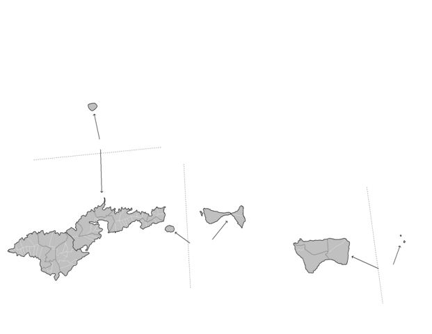
| Beschrijving | Map of the administrative divisions of American Samoa. Map is to scale, with distances between the various islands displayed. Created by Rarelibra 17:29, 11 January 2008 (UTC) for public domain use, using MapInfo Professional v8.5 and various mapping resources. |
| Datum | 11 januari 2008 (originele uploaddatum) |
| Bron | Geen machineleesbare bron opgegeven. Eigen werk aangenomen (gebaseerd op auteursrechtclaims). |
| Auteur | Geen machineleesbare auteur aanwezig. Op basis van auteursrechtclaims wordt auteur Rarelibra aangenomen. |
Licentie
| Ik, de auteursrechthebbende van dit werk, geef dit werk vrij in het publieke domein. Dit is wereldwijd van toepassing. In sommige landen is dit wettelijk niet mogelijk; in die gevallen geldt: Ik sta iedereen toe dit werk voor eender welk doel te gebruiken, zonder enige voorwaarden, tenzij zulke voorwaarden door de wet worden voorgeschreven. |
Bestandsgeschiedenis
Klik op een datum/tijd om het bestand te zien zoals het destijds was.
| Datum/tijd | Miniatuur | Afmetingen | Gebruiker | Opmerking | |
|---|---|---|---|---|---|
| huidige versie | 4 dec 2010 17:51 | | 2.112 × 1.632 (44 kB) | Beao | Transparent. |
| 11 jan 2008 19:29 |  | 2.112 × 1.632 (37 kB) | Rarelibra | Map of the administrative divisions of American Samoa. Map is to scale, with distances between the various islands displayed. Created by ~~~~ for public domain use, using MapInfo Professional v8.5 and various mapping resources. |
Bestandsgebruik
Dit bestand wordt op de volgende pagina gebruikt:
Globaal bestandsgebruik
De volgende andere wiki's gebruiken dit bestand:
- Gebruikt op fy.wikipedia.org
- Gebruikt op ja.wikipedia.org
- Gebruikt op mt.wikipedia.org