
Bestand:Perryville 1400.png
Grootte van deze voorvertoning: 432 × 600 pixels. Andere resoluties: 173 × 240 pixels | 346 × 480 pixels | 553 × 768 pixels | 737 × 1.024 pixels | 2.401 × 3.334 pixels.
Oorspronkelijk bestand (2.401 × 3.334 pixels, bestandsgrootte: 7,58 MB, MIME-type: image/png)
| Dit is een bestand van Wikimedia Commons. Onderstaande beschrijving komt van de beschrijving van het bestand daar. |
Beschrijving
| Beschrijving |
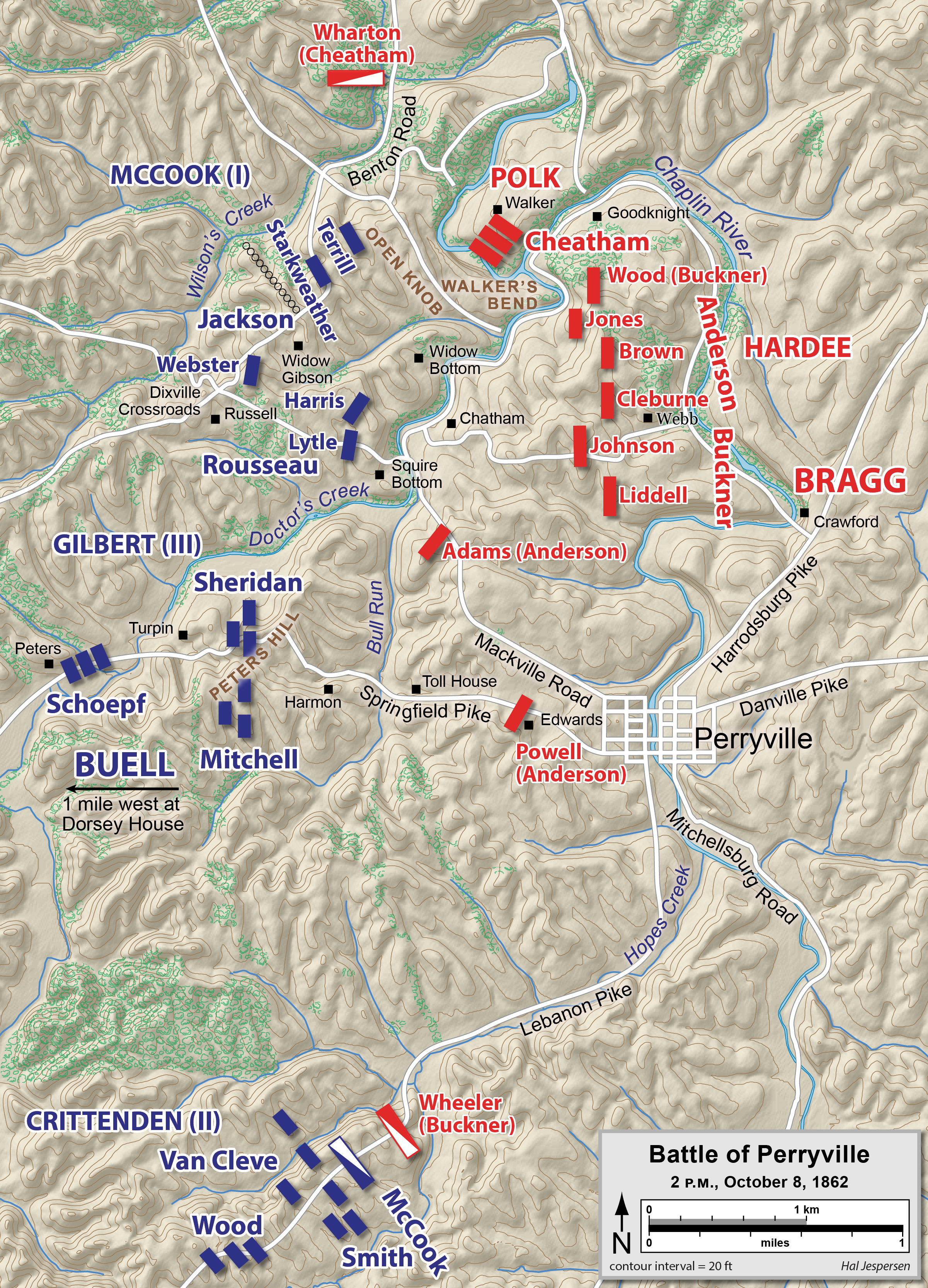
English: Map of the Battle of Perryville of the American Civil War, drawn in Adobe Illustrator CC by Hal Jespersen. Graphic source file is available at http://www.cwmaps.com/ |
| Datum | 31 december 2007 (originele uploaddatum) |
| Bron | Verplaatst vanaf en.wikipedia naar Commons. |
| Auteur | Hal Jespersen at en.wikipedia |
Licentie
Dit bestand is gelicenseerd onder de Creative Commons-licentie Naamsvermelding 3.0 Unported
Naamsvermelding: Map by Hal Jespersen, www.cwmaps.com
- De gebruiker mag:
- Delen – het werk kopiëren, verspreiden en doorgeven
- Remixen – afgeleide werken maken
- Onder de volgende voorwaarden:
- naamsvermelding – U moet op een gepaste manier aan naamsvermelding doen, een link naar de licentie geven, en aangeven of er wijzigingen in het werk zijn aangebracht. U mag dit op elke redelijke manier doen, maar niet zodanig dat de indruk wordt gewekt dat de licentiegever instemt met uw werk of uw gebruik van zijn werk.
Oorspronkelijk uploadlogboek
De oorspronkelijke beschrijving van deze afbeelding stond hier. Alle volgende gebruikersnamen verwijzen naar en.wikipedia.
- 2007-12-31 23:53 Hlj 1500×2313× (1492121 bytes) Map of the [[Battle of Perryville]] of the American Civil War, drawn in Adobe Illustrator CS3 by Hal Jespersen. Graphic source file is available at http://www.posix.com/CWmaps/ [Replaced with lower res version.]
- 2007-12-31 23:39 Hlj 3243×5000× (1905412 bytes) Map of the [[Battle of Perryville]] of the American Civil War, drawn in Adobe Illustrator CS3 by Hal Jespersen. Graphic source file is available at http://www.posix.com/CWmaps/
Bestandsgeschiedenis
Klik op een datum/tijd om het bestand te zien zoals het destijds was.
| Datum/tijd | Miniatuur | Afmetingen | Gebruiker | Opmerking | |
|---|---|---|---|---|---|
| huidige versie | 19 aug 2021 22:41 | | 2.401 × 3.334 (7,58 MB) | Hlj | Improved topographic background and graphical appearance, corrected some unit state abbreviations. |
| 2 apr 2015 17:35 |  | 6.488 × 10.026 (5,42 MB) | Hlj | Update with some spelling and label overlap fixes, plus some minor graphical improvements. Same license. | |
| 26 mrt 2011 18:35 |  | 1.600 × 2.473 (1,64 MB) | Hlj | Update to more recent graphic style, including hills, rivers, and roads. Added legend. {{cc-by-3.0|Map by Hal Jespersen, www.posix.com/CW}} | |
| 26 mrt 2011 18:32 |  | 3.244 × 5.013 (2,19 MB) | Hlj | Update to more recent graphic style, including hills, rivers, and roads. Added legend. {{cc-by-3.0|Map by Hal Jespersen, www.posix.com/CW}} | |
| 24 jan 2010 16:23 |  | 1.500 × 2.313 (1,42 MB) | BotMultichill | {{BotMoveToCommons|en.wikipedia|year={{subst:CURRENTYEAR}}|month={{subst:CURRENTMONTHNAME}}|day={{subst:CURRENTDAY}}}} {{Information |Description={{en|Map of the en:Battle of Perryville of the American Civil War, drawn in Adobe Illustrator CS3 by |
Bestandsgebruik
Dit bestand wordt op de volgende pagina gebruikt:
Globaal bestandsgebruik
De volgende andere wiki's gebruiken dit bestand:
- Gebruikt op da.wikipedia.org
- Gebruikt op en.wikipedia.org