
Bestand:Petsamo.png

Grootte van deze voorvertoning: 507 × 599 pixels. Andere resoluties: 203 × 240 pixels | 406 × 480 pixels.
Oorspronkelijk bestand (800 × 945 pixels, bestandsgrootte: 30 kB, MIME-type: image/png)
| Dit is een bestand van Wikimedia Commons. Onderstaande beschrijving komt van de beschrijving van het bestand daar. |
| Beschrijving |
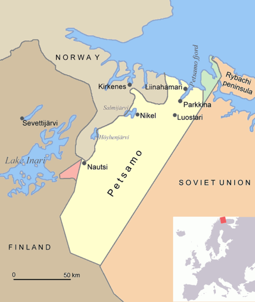
English: Map of Petsamo area in northern Finland/Soviet Union/Russia. The green area is the Finnish part of the Rybachi peninsula (Kalastajasaarento) which was ceded to the Soviet Union after the Winter War. The red area is the Jäniskoski-Niskakoski area ceded to the Soviet Union in 1947. |
| Bron | Eigen werk |
| Auteur | Jniemenmaa |
Ik, de auteursrechthebbende van dit werk, maak het hierbij onder de volgende licenties beschikbaar:

|
Toestemming wordt verleend voor het kopiëren, verspreiden en/of wijzigen van dit document onder de voorwaarden van de GNU-licentie voor vrije documentatie, versie 1.2 of enige latere versie als gepubliceerd door de Free Software Foundation; zonder Invariant Sections, zonder Front-Cover Texts, en zonder Back-Cover Texts. Een kopie van de licentie is opgenomen in de sectie GNU-licentie voor vrije documentatie. |
| Dit bestand is gelicenseerd onder de Creative Commons-licentie Naamsvermelding-Gelijk delen 3.0 Unported | ||
| ||
| Deze licentietag is toegevoegd aan dit bestand in verband met de GFDL licentie-update. |
U mag zelf één van de licenties kiezen.

|
Deze kaartafbeelding zou opnieuw moeten worden aangemaakt als een SVG-bestand door vectorafbeeldingen te gebruiken. Dit heeft een aantal voordelen; zie Commons:Media for cleanup voor meer informatie. Als er een SVG-formaat van deze afbeelding bestaat, dan deze graag uploaden. Nadat u dit heeft gedaan, gelieve dit sjabloon te vervangen door het sjabloon {{vector version available|nieuwe bestandsnaam.svg}} op deze afbeeldingspagina.
|
Bestandsgeschiedenis
Klik op een datum/tijd om het bestand te zien zoals het destijds was.
| Datum/tijd | Miniatuur | Afmetingen | Gebruiker | Opmerking | |
|---|---|---|---|---|---|
| huidige versie | 17 jun 2015 21:08 | | 800 × 945 (30 kB) | Hohum | Clearer |
| 1 aug 2005 19:48 |  | 800 × 945 (70 kB) | Jniemenmaa | Map of Petsamo area in northern Finland/Soviet Union/Russia. The green area is the Finnish part of the Rybachi peninsula which was ceded to the Soviet Union after the Winter War. The Red area is the Jäniskoksi area ceded to the SU some years after the C |
Bestandsgebruik
Dit bestand wordt op de volgende 3 pagina's gebruikt:
Globaal bestandsgebruik
De volgende andere wiki's gebruiken dit bestand:
- Gebruikt op ar.wikipedia.org
- Gebruikt op ba.wikipedia.org
- Gebruikt op ca.wikipedia.org
- Gebruikt op cs.wikipedia.org
- Gebruikt op da.wikipedia.org
- Gebruikt op de.wikipedia.org
- Gebruikt op en.wikipedia.org
- Central European Time
- User:Jniemenmaa/images
- Rybachy Peninsula
- Walter Schuck
- Heinrich Bartels
- Pechengsky District
- Jakob Norz
- Operation EF (1941)
- Norway–Russia border
- Rudi Linz
- August Mors
- Jäniskoski-Niskakoski territory
- User:Falcaorib/Russia and Soviet Union
- User:Falcaorib/Sweden and Finland
- Friedrich-Wilhelm Strakeljahn
- Gebruikt op eo.wikipedia.org
- Gebruikt op es.wikipedia.org
- Gebruikt op eu.wikipedia.org
- Gebruikt op fi.wikipedia.org
- Gebruikt op fr.wikipedia.org
- Gebruikt op gl.wikipedia.org
- Gebruikt op hu.wikipedia.org
- Gebruikt op it.wikipedia.org
- Gebruikt op nn.wikipedia.org
Globaal gebruik van dit bestand bekijken.