
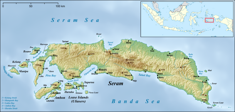
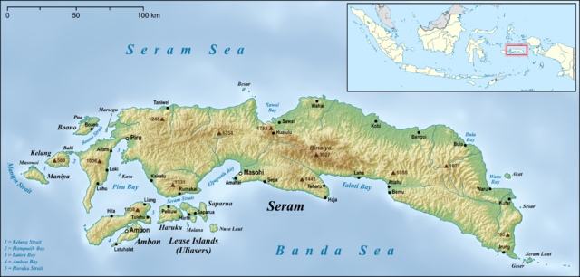
Bestand:Seram en.png

Grootte van deze voorvertoning: 800 × 382 pixels. Andere resoluties: 320 × 153 pixels | 640 × 306 pixels | 1.024 × 489 pixels | 1.280 × 612 pixels | 2.756 × 1.317 pixels.
Oorspronkelijk bestand (2.756 × 1.317 pixels, bestandsgrootte: 2,59 MB, MIME-type: image/png)
| Dit is een bestand van Wikimedia Commons. Onderstaande beschrijving komt van de beschrijving van het bestand daar. |
Beschrijving
| Beschrijving | |
| Datum | |
| Bron |
own work, used:
|
| Auteur | Lencer |
| Andere versies |
|


|
Deze kaart is gemaakt of verbeterd in de Duitse Kartenwerkstatt (Map Lab). Je kunt ook zelf kaarten ter verbetering voorstellen.
|
Licentie
Ik, de auteursrechthebbende van dit werk, maak het hierbij onder de volgende licentie beschikbaar:
Dit bestand is gelicenseerd onder de Creative Commons-licentie Naamsvermelding-Gelijk delen 3.0 Unported
- De gebruiker mag:
- Delen – het werk kopiëren, verspreiden en doorgeven
- Remixen – afgeleide werken maken
- Onder de volgende voorwaarden:
- naamsvermelding – U moet op een gepaste manier aan naamsvermelding doen, een link naar de licentie geven, en aangeven of er wijzigingen in het werk zijn aangebracht. U mag dit op elke redelijke manier doen, maar niet zodanig dat de indruk wordt gewekt dat de licentiegever instemt met uw werk of uw gebruik van zijn werk.
- Gelijk delen – Als u het werk heeft geremixt, veranderd, of erop heeft voortgebouwd, moet u het gewijzigde materiaal verspreiden onder dezelfde licentie als het oorspronkelijke werk, of een daarmee compatibele licentie.
Bestandsgeschiedenis
Klik op een datum/tijd om het bestand te zien zoals het destijds was.
| Datum/tijd | Miniatuur | Afmetingen | Gebruiker | Opmerking | |
|---|---|---|---|---|---|
| huidige versie | 18 jun 2015 07:05 | | 2.756 × 1.317 (2,59 MB) | Lencer | small fix |
| 17 jun 2015 08:22 |  | 2.756 × 1.317 (2,59 MB) | Lencer | small fixes | |
| 17 jun 2015 07:42 |  | 2.756 × 1.317 (2,59 MB) | Lencer | == {{int:filedesc}} == {{Information |Description= {{en|Map of Seram Island and also Ambon Island and Lease Islands}} {{de|Karte der Insel Seram, sowie [[:de:Ambon (Insel)|Am... |
Bestandsgebruik
Dit bestand wordt op de volgende 2 pagina's gebruikt:
Globaal bestandsgebruik
De volgende andere wiki's gebruiken dit bestand:
- Gebruikt op af.wikipedia.org
- Gebruikt op ar.wikipedia.org
- Gebruikt op ast.wikipedia.org
- Gebruikt op be.wikipedia.org
- Gebruikt op bg.wikipedia.org
- Gebruikt op bn.wikipedia.org
- Gebruikt op ca.wikipedia.org
- Gebruikt op ceb.wikipedia.org
- Gebruikt op cs.wikipedia.org
- Gebruikt op cy.wikipedia.org
- Gebruikt op da.wikipedia.org
- Gebruikt op de.wikipedia.org
- Gebruikt op el.wikipedia.org
- Gebruikt op en.wikipedia.org
- Seram Island
- Pattimura International Airport
- Streak-breasted fantail
- Central Maluku Regency
- West Seram Regency
- East Seram Regency
- Masohi
- Tehoru
- Boano
- Masiwang River
- Kawa River
- Sapalewa River
- Tala River
- Salawai River
- Bengoi
- Bula, Indonesia
- Taniwel
- Piru, Indonesia
- Kairatu
- Ariate
- Luhu, Indonesia
- Kulur, Indonesia
- Loki, Indonesia
- Module:Location map/data/Indonesia Seram/doc
- Amahai
- Atiahu
- Bemu
- Wikipedia:Graphics Lab/Map workshop/Archive/Jun 2015
Globaal gebruik van dit bestand bekijken.