
Bestand:South Shetland Islands Map.png
Grootte van deze voorvertoning: 800 × 551 pixels. Andere resoluties: 320 × 220 pixels | 640 × 441 pixels | 1.103 × 760 pixels.
Oorspronkelijk bestand (1.103 × 760 pixels, bestandsgrootte: 35 kB, MIME-type: image/png)
| Dit is een bestand van Wikimedia Commons. Onderstaande beschrijving komt van de beschrijving van het bestand daar. |
| Beschrijving |
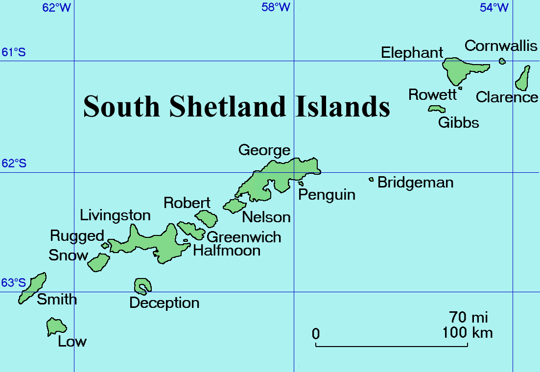
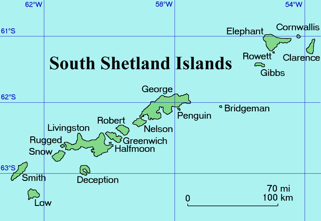
English: Map of the South Shetland Islands
Català: Mapa de les illes Shetland del Sud.
Deutsch: Karte der Südlichen Shetlandinseln
Español: Mapa de las Islas Shetland del Sur
Italiano: Una mappa delle Isole Shetland Meridionali
Русский: Карта Южных Шетландских островов (английский вариант)
Slovenščina: Zemljevid otočja |
| Datum | Commons upload by Snowdog |
| Bron |
Originally from en.wikipedia; description page is (was) here
|
| Auteur | User Topbanana on en.wikipedia |
| Toestemming (Hergebruik van dit bestand) |
PD-self |
| |
Dit bestand is door Topbanana op Wikimedia Commons, in het publieke domein geplaatst. Dit is wereldwijd van toepassing. In sommige landen is dit niet mogelijk; in die gevallen geldt: |
Bestandsgeschiedenis
Klik op een datum/tijd om het bestand te zien zoals het destijds was.
| Datum/tijd | Miniatuur | Afmetingen | Gebruiker | Opmerking | |
|---|---|---|---|---|---|
| huidige versie | 27 feb 2005 22:11 | | 1.103 × 760 (35 kB) | Snowdog | Map of the South Shetland Islands |
Bestandsgebruik
Dit bestand wordt op de volgende 6 pagina's gebruikt:
Globaal bestandsgebruik
De volgende andere wiki's gebruiken dit bestand:
- Gebruikt op af.wikipedia.org
- Gebruikt op ang.wikipedia.org
- Gebruikt op ar.wikipedia.org
- Gebruikt op ast.wikipedia.org
- Gebruikt op az.wikipedia.org
- Gebruikt op ba.wikipedia.org
- Gebruikt op be.wikipedia.org
- Gebruikt op bg.wikipedia.org
- Gebruikt op br.wikipedia.org
- Gebruikt op ca.wikipedia.org
- Gebruikt op ceb.wikipedia.org
- Gebruikt op ce.wikipedia.org
- Gebruikt op cs.wikipedia.org
- Gebruikt op cv.wikipedia.org
- Gebruikt op da.wikipedia.org
- Gebruikt op de.wikipedia.org
- Gebruikt op el.wikipedia.org
- Gebruikt op en.wikipedia.org
- South Shetland Islands
- Gibbs Island (South Shetland Islands)
- Clarence Island (South Shetland Islands)
- Cornwallis Island (South Shetland Islands)
- Seal Islands (South Shetland Islands)
- Benjamin Morrell
- Endurance Point
- Cape Bowles
- Chinstrap Cove
- Walker Point
- Jubilee Peak
- Sultan Glacier
- Furness Glacier
- Gnomon Island
- Cape Lloyd
- Highton Glacier
- Ravelin Ridge
- Cape Valentine
- Wordie Seamount
Globaal gebruik van dit bestand bekijken.