
Bestand:Tri-State Tornado trackmap (PAH).jpg
Geen hogere resolutie beschikbaar.
Tri-State_Tornado_trackmap_(PAH).jpg (555 × 542 pixels, bestandsgrootte: 80 kB, MIME-type: image/jpeg)
| Dit is een bestand van Wikimedia Commons. Onderstaande beschrijving komt van de beschrijving van het bestand daar. |
.jpg)
Beschrijving
| Beschrijving |
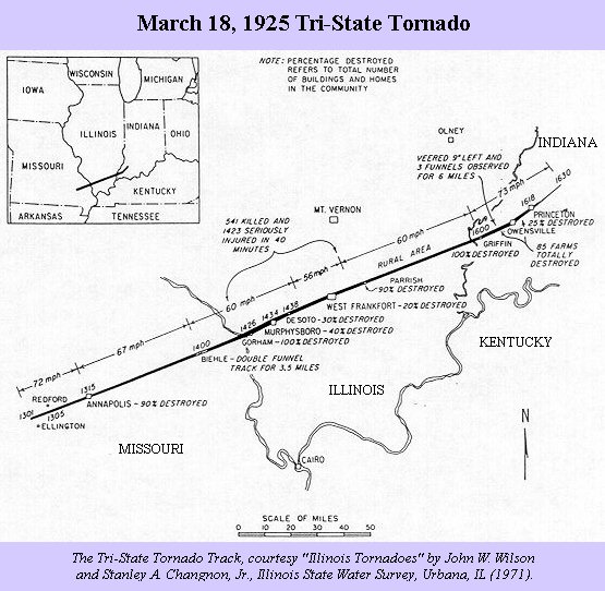
English: A map of the track of the 219-mile, 3.5 hour Tri-State Tornado which killed 695 in Missouri, Illinois, and Indiana on 18 March 1925. |
| Bron | http://www.weather.gov/pah/1925Tornado_tt |
| Auteur | USGov-NOAA |
| Andere versies | File:Tri-State Tornado trackmap cropped.png |
Licentie
Deze afbeelding is in het publiek domein omdat het materiaal bevat dat oorspronkelijk van de National Oceanic and Atmospheric Administration kwam in de Verenigde Staten en genomen of gemaakt is tijdens de officiële werkzaamheden van een werknemer.
|
Bestandsgeschiedenis
Klik op een datum/tijd om het bestand te zien zoals het destijds was.
| Datum/tijd | Miniatuur | Afmetingen | Gebruiker | Opmerking | |
|---|---|---|---|---|---|
| huidige versie | 13 nov 2006 22:59 | | 555 × 542 (80 kB) | Skyodyssey~commonswiki | A map of the track of the 219-mile, 3.5 hour Tri-State Tornado which killed 695 in Missouri, Illinois, and Indiana on 18 March 1925. http://www.crh.noaa.gov/pah/1925/tt_body.php Category:Tornadoes |
Bestandsgebruik
Dit bestand wordt op de volgende pagina gebruikt:
Globaal bestandsgebruik
De volgende andere wiki's gebruiken dit bestand:
- Gebruikt op ar.wikipedia.org
- Gebruikt op de.wikipedia.org
- Gebruikt op en.wikipedia.org
- Gebruikt op es.wikipedia.org
- Gebruikt op no.wikipedia.org
- Gebruikt op pl.wikipedia.org
- Gebruikt op pt.wikipedia.org
.jpg)