
Bestand:WalesCaerphilly.png
Geen hogere resolutie beschikbaar.
WalesCaerphilly.png (200 × 225 pixels, bestandsgrootte: 22 kB, MIME-type: image/png)
| Dit is een bestand van Wikimedia Commons. Onderstaande beschrijving komt van de beschrijving van het bestand daar. |
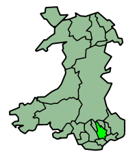
Caerphilly in Wales
Map by en:User:Morwen
Русский: Карта_Кэрфилли

|
Toestemming wordt verleend voor het kopiëren, verspreiden en/of wijzigen van dit document onder de voorwaarden van de GNU-licentie voor vrije documentatie, versie 1.2 of enige latere versie als gepubliceerd door de Free Software Foundation; zonder Invariant Sections, zonder Front-Cover Texts, en zonder Back-Cover Texts. Een kopie van de licentie is opgenomen in de sectie GNU-licentie voor vrije documentatie. |
| Dit bestand is gelicenseerd onder de Creative Commons-licentie Naamsvermelding-Gelijk delen 3.0 Unported | ||
| ||
| Deze licentietag is toegevoegd aan dit bestand in verband met de GFDL licentie-update. |
Bestandsgeschiedenis
Klik op een datum/tijd om het bestand te zien zoals het destijds was.
| Datum/tijd | Miniatuur | Afmetingen | Gebruiker | Opmerking | |
|---|---|---|---|---|---|
| huidige versie | 27 jun 2006 01:27 | | 200 × 225 (22 kB) | Nichtbesserwisser | Caerphilly in Wales Map by en:User:Morwen Category:Maps of Wales {{GFDL}} |
Bestandsgebruik
Dit bestand wordt op de volgende 2 pagina's gebruikt:
Globaal bestandsgebruik
De volgende andere wiki's gebruiken dit bestand:
- Gebruikt op be.wikipedia.org
- Gebruikt op bg.wikipedia.org
- Gebruikt op br.wikipedia.org
- Gebruikt op en.wikipedia.org
- Caerphilly
- A465 road
- Taff Trail
- Rhymney line
- Monmouthshire and Brecon Canal
- Ebbw Valley Railway
- Hengoed railway station
- Transport in Wales
- Pengam railway station
- Rhymney railway station
- Bargoed railway station
- Pontlottyn railway station
- Tir-Phil railway station
- Brithdir railway station
- Gilfach Fargoed railway station
- Ystrad Mynach railway station
- Llanbradach railway station
- Aber railway station
- Caerphilly railway station
- Risca and Pontymister railway station
- Crosskeys railway station
- Newbridge railway station (Wales)
- Newport Bus
- Celtic Trail cycle route
- A469 road
- A468 road
- National Cycle Route 4
- Stagecoach South Wales
- Rhymney Valley Ridgeway Walk
- Cistercian Way (Wales)
- Sirhowy Valley Ridgeway Walk
- Energlyn & Churchill Park railway station
- Template:Transport in Caerphilly County Borough
- Trunk roads in Wales
- Blackwood Interchange
- Bargoed Interchange
- Gebruikt op gv.wikipedia.org
- Gebruikt op no.wikipedia.org
- Gebruikt op pt.wikipedia.org
- Gebruikt op ru.wikipedia.org
- Gebruikt op uk.wikipedia.org