
Bestand:WalesPembrokeshire.png
Geen hogere resolutie beschikbaar.
WalesPembrokeshire.png (200 × 225 pixels, bestandsgrootte: 22 kB, MIME-type: image/png)
| Dit is een bestand van Wikimedia Commons. Onderstaande beschrijving komt van de beschrijving van het bestand daar. |
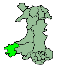
Pembrokeshire in Wales
Русский: Карта_Пембрукшир
Map by en:User:Morwen

|
Toestemming wordt verleend voor het kopiëren, verspreiden en/of wijzigen van dit document onder de voorwaarden van de GNU-licentie voor vrije documentatie, versie 1.2 of enige latere versie als gepubliceerd door de Free Software Foundation; zonder Invariant Sections, zonder Front-Cover Texts, en zonder Back-Cover Texts. Een kopie van de licentie is opgenomen in de sectie GNU-licentie voor vrije documentatie. |
| Dit bestand is gelicenseerd onder de Creative Commons-licentie Naamsvermelding-Gelijk delen 3.0 Unported | ||
| ||
| Deze licentietag is toegevoegd aan dit bestand in verband met de GFDL licentie-update. |
Bestandsgeschiedenis
Klik op een datum/tijd om het bestand te zien zoals het destijds was.
| Datum/tijd | Miniatuur | Afmetingen | Gebruiker | Opmerking | |
|---|---|---|---|---|---|
| huidige versie | 27 jun 2006 01:38 | | 200 × 225 (22 kB) | Nichtbesserwisser | Pembrokeshire in Wales Map by en:User:Morwen Category:Maps of Wales {{GFDL}} |
Bestandsgebruik
Dit bestand wordt op de volgende pagina gebruikt:
Globaal bestandsgebruik
De volgende andere wiki's gebruiken dit bestand:
- Gebruikt op be.wikipedia.org
- Gebruikt op bg.wikipedia.org
- Gebruikt op br.wikipedia.org
- Gebruikt op cy.wikipedia.org
- Tyddewi
- Sir Benfro
- Abergwaun
- Castell Penfro
- Bae Sain Ffraid
- Parc Cenedlaethol Arfordir Penfro
- Castell Maenorbŷr
- Capel Llwyn-yr-hwrdd
- Brynberian
- Afon Nyfer
- Cilgeti
- Stepaside
- Wdig
- Marloes
- Bae Abergwaun
- Llanfyrnach
- Ynys Sgomer
- Radio Pembrokeshire
- Abercuch
- Castell Caeriw
- Canolfan yr Urdd Pentre Ifan
- Melin Tregwynt
- Llanychaer
- Rhos-y-bwlch
- Trefin
- Pontfaen
- Casnewydd-bach
- Abaty Llandudoch
- Eglwyswen
- Nodyn:Eginyn Sir Benfro
- Afon Gwaun
- Priordy Hwlffordd
- Priordy Penfro
- Priordy Pyll
- Priordy Ynys Bŷr
- Foel Feddau
- Tre-groes, Sir Benfro
- Hermon, Sir Benfro
- Tegryn
- Star, Sir Benfro
- Manorowen
- Tremarchog
- Trefaser
- Is Nyfer
- Pentre Galar
- Carn Menyn
- Cerrig Garn Wen
Globaal gebruik van dit bestand bekijken.