
Bestand:Xhosa1851.jpg
Xhosa1851.jpg (512 × 312 pixels, bestandsgrootte: 60 kB, MIME-type: image/jpeg)
| Dit is een bestand van Wikimedia Commons. Onderstaande beschrijving komt van de beschrijving van het bestand daar. |
Beschrijving
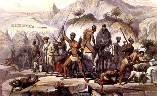
| Kafir and Hottentot war-party | |
|---|---|
| Kunstenaar |
H. R (Hugh Robinson) |
| Auteur |
Lumley Graham, and Hugh Robinson, Officers of the 43rd Lt.-Infantry |
| Titel |
Kafir and Hottentot war-party |
| Soort object | prent |
| Beschrijving |
English: A Kafir and Hottentot war-party scene, from Scenes in Kafirland, and Incidents in the Kafir War of 1851-2-3,
FIRST EDITION, [1854] The war started at Kaalhoek during Christmas time, 1850, and by 1852 the Water Kloof was secured by colonial forces. The ringleaders of the insurgents surrendered in 1853. Afrikaans: Insurgente van die 8ste Grensoorlog (ook: Bonte Oorlog), wat 'n posisie in die Water Kloof verdedig in die tweede jaar van die oorlog, 1851. Xhosa, Katrivier-khoikhoi en drosters word hier uitgebeeld. 'n Benaderde ligging word onder aangegee. Die oorlog het tydens Kersfees 1850 te Kaalhoek uitgebreek, en eers in 1852 is die insurgente uit die Water Kloof verdryf. Die insurgente se ringleiers het in 1853 oorgegee. |
| Datum | 1854 |
| Bron/fotograaf | Anne S.K Brown Military Collection |
| Objectlocatie | | Deze en andere afbeeldingen in: OpenStreetMap |
|---|
Licentie
|
Het tweedimensionale kunstwerk afgebeeld op deze afbeelding valt in het publiek domein omdat:
Reproducties van het werk kunnen ook worden beschouwd als publiek domein omdat ze geen oorspronkelijk karakter hebben. Dit geldt voor reproducties gemaakt in de Verenigde Staten (zie Bridgeman Art Library v. Corel Corp.), Duitsland en veel andere landen.
| ||||
Oorspronkelijk uploadlogboek
Verplaatst vanaf en.wikipedia naar Commons door Naudefj met behulp van CommonsHelper.
- 2007-06-05 16:28 Dr. Blofeld 512×312× (61493 bytes) *http://home.earthlink.net/~cyberkiwi/soldiers/cape32.jpg Painting of the Xhosa wars
Bestandsgeschiedenis
Klik op een datum/tijd om het bestand te zien zoals het destijds was.
| Datum/tijd | Miniatuur | Afmetingen | Gebruiker | Opmerking | |
|---|---|---|---|---|---|
| huidige versie | 1 jan 2013 20:04 | | 512 × 312 (60 kB) | File Upload Bot (Magnus Manske) | Transfered from en.wikipedia by User:naudefj using CommonsHelper |
Bestandsgebruik
Dit bestand wordt op de volgende pagina gebruikt:
Globaal bestandsgebruik
De volgende andere wiki's gebruiken dit bestand:
- Gebruikt op af.wikipedia.org
- Gebruikt op ar.wikipedia.org
- Gebruikt op ast.wikipedia.org
- Gebruikt op de.wikipedia.org
- Gebruikt op el.wikipedia.org
- Gebruikt op en.wikipedia.org
- Gebruikt op es.wikipedia.org
- Gebruikt op he.wikipedia.org
- Gebruikt op it.wikipedia.org
- Gebruikt op no.wikipedia.org
- Gebruikt op uk.wikipedia.org
- Gebruikt op www.wikidata.org
- Gebruikt op xh.wikipedia.org