
Bestand:Iceland Mid-Atlantic Ridge map.svg

Afmetingen van deze voorvertoning van het type PNG van dit SVG-bestand: 376 × 390 pixels Andere resoluties: 231 × 240 pixels | 463 × 480 pixels | 740 × 768 pixels | 987 × 1.024 pixels | 1.974 × 2.048 pixels.
Oorspronkelijk bestand (SVG-bestand, nominaal 376 × 390 pixels, bestandsgrootte: 129 kB)
| Dit is een bestand van Wikimedia Commons. Onderstaande beschrijving komt van de beschrijving van het bestand daar. |
Beschrijving
| Beschrijving | |
| Datum | |
| Bron | http://pubs.usgs.gov/gip/dynamic/understanding.html |
| Auteur | http://pubs.usgs.gov/gip/dynamic/understanding.html |
| Andere versies |
|


Licentie
Deze afbeelding bevindt zich in het publiek domein omdat het materiaal bevat dat oorspronkelijk afkomstig is van de United States Geological Survey, een agentschap van de United States Department of the Interior. Voor meer informatie, zie het officiële USGS-auteursrechtenbeleid
|
| Aantekeningen | Deze afbeelding is aangetekend: Bekijk de aantekeningen op Commons |
Bestandsgeschiedenis
Klik op een datum/tijd om het bestand te zien zoals het destijds was.
| Datum/tijd | Miniatuur | Afmetingen | Gebruiker | Opmerking | |
|---|---|---|---|---|---|
| huidige versie | 10 jan 2014 20:48 | | 376 × 390 (129 kB) | Amitchell125 | text improved |
| 26 feb 2010 16:42 |  | 376 × 390 (68 kB) | Beao | Tweak. | |
| 26 feb 2010 16:40 |  | 376 × 390 (68 kB) | Beao | Tweak. | |
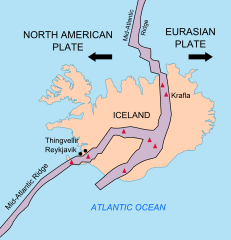
| 26 feb 2010 16:37 |  | 376 × 390 (68 kB) | Beao | == Summary == {{Information |Description={{en|1=Map showing the Mid-Atlantic Ridge splitting Iceland and separating the North American and Eurasian Plates. The map also shows Reykjavik, the capital of Iceland, the Thingvellir area, and the locations of so |
Bestandsgebruik
Dit bestand wordt op de volgende 3 pagina's gebruikt:
Globaal bestandsgebruik
De volgende andere wiki's gebruiken dit bestand:
- Gebruikt op be-tarask.wikipedia.org
- Gebruikt op bn.wikipedia.org
- Gebruikt op ca.wikipedia.org
- Gebruikt op en.wikipedia.org
- Gebruikt op en.wikivoyage.org
- Gebruikt op fi.wikipedia.org
- Gebruikt op hr.wikipedia.org
- Gebruikt op id.wikipedia.org
- Gebruikt op it.wikipedia.org
- Gebruikt op ko.wikipedia.org
- Gebruikt op lb.wikipedia.org
- Gebruikt op no.wikipedia.org
- Gebruikt op pl.wikipedia.org
- Gebruikt op simple.wikipedia.org
- Gebruikt op sl.wikipedia.org
- Gebruikt op sr.wikipedia.org
- Gebruikt op sv.wikipedia.org
- Gebruikt op tr.wikipedia.org
- Gebruikt op uk.wikipedia.org
- Gebruikt op zh.wikipedia.org
- Gebruikt op zh.wikivoyage.org